
Maps: the toxic vinyl chloride train route from Texas to New Jersey
Toxic Cargo: How rail transport of vinyl chloride puts millions at risk, an analysis one year after the Ohio train derailment
The toxic vinyl chloride train route from Texas to New Jersey
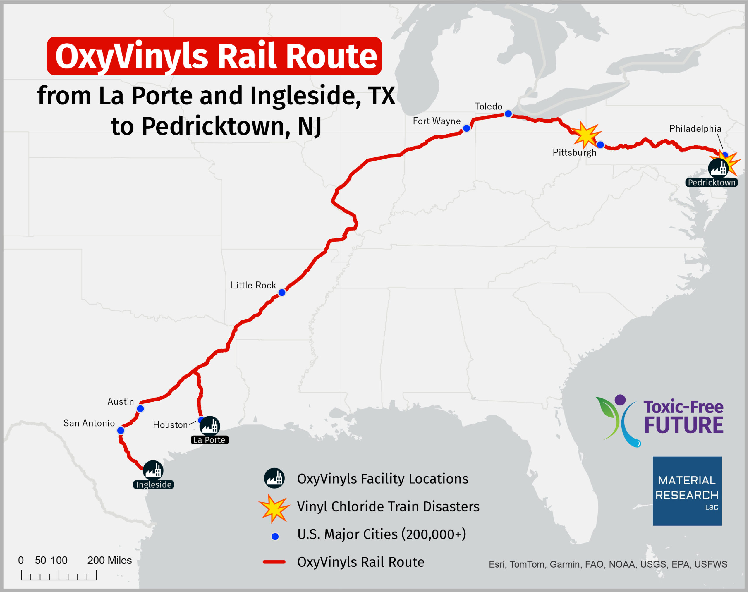
As noted above, we mapped the most likely rail routes from OxyVinyls’ vinyl chloride plants in Texas to their destination PVC factories. The longest route—and the one associated with two disasters in the last dozen years—is the route to Pedricktown, New Jersey, where OxyVinyls and its partner company Orbia both manufacture PVC.
The map reveals for the first time the most likely train route that vinyl chloride travels from OxyVinyls plants in Texas through hundreds of towns along 1,979 miles of tracks through major cities including Houston, TX; Philadelphia, PA; San Antonio, TX; Austin, TX; Pittsburgh, PA; Toledo, OH; Fort Wayne, IN; Little Rock, AR; and many other cities and towns. See Material Research’s Methodology (PDF) for a detailed description of how this map was created and for population calculations.
Communities and children at risk
People who live, work, or attend schools near these rail lines face serious risks in the event of a major disaster, as was seen in East Palestine, Ohio and Paulsboro, New Jersey. In the event of a major vinyl chloride rail spill or fire, the Department of Transportation (DOT) Emergency Response Guidebook (ERG) recommends an initial downwind evacuation of 1/2 mile in the event of a large vinyl chloride spill, and an initial evacuation of one mile in all directions if a rail car involving vinyl chloride is involved in a fire.26
Nationwide, we estimate that more than three million people live within a mile of this train route, and an estimated 672,660 children attend 1,525 schools (1,249 public schools and 276 private schools) within a mile of the train route between Texas and New Jersey. These people are at risk in the event of a catastrophic train wreck, as was seen in East Palestine, Ohio and Paulsboro, New Jersey.
We evaluated the most populated cities along the OxyVinyls train routes, obtaining information about the number of people living within one mile of a point the route crosses the city as well as the racial composition.e The numbers we present therefore represent a low-end estimate of the number of people living and the number of schools near the train route in these eight major cities. We found that in the eight largest cities, at least 158,465 people live within a mile of the train route and 67 schools are also located in close proximity to the tracks. In some cases, such as in Philadelphia, San Antonio, and Houston, most people living near the vinyl chloride train route are people of color.
The results of our analysis are as follows, with cities having the largest population near the trail route listed first:
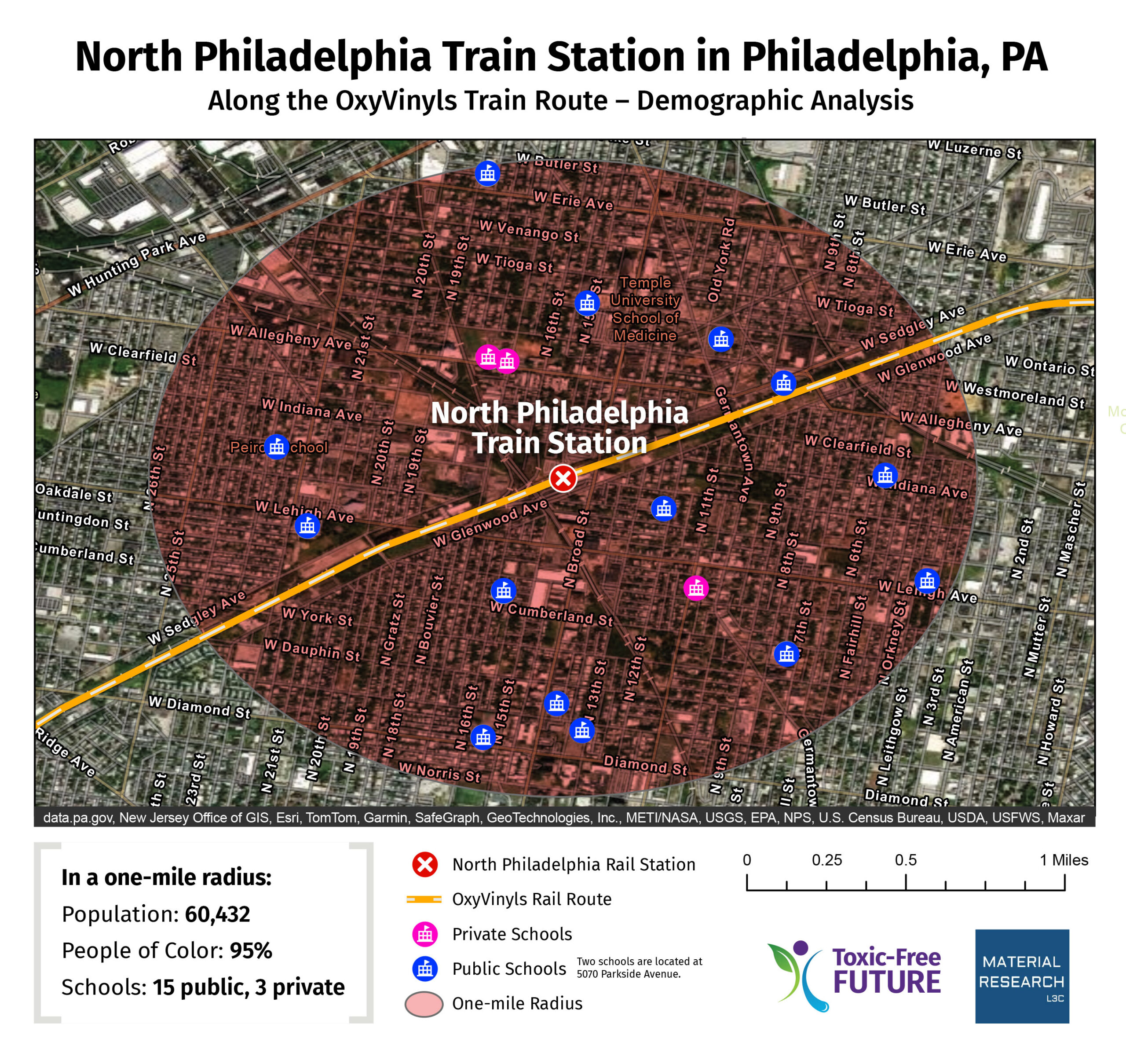
- Philadelphia, PA – Residences of 60,432 people and 18 schools are located within a one-mile radius of the vinyl chloride train route through Philadelphia; 95% of this population are people of color, compared to the national average of 41%.27
- Pittsburgh, PA – Residences of 22,570 people and 11 schools are located within a one-mile radius of the vinyl chloride train route through Pittsburgh; 42% of this population are people of color.28
- Austin, TX – Residences of 20,677 people and seven schools are located within a one-mile radius of the vinyl chloride train route through Austin; 25% of this population are people of color.29
- San Antonio, TX – Residences of 15,176 people and 12 schools are located within a one-mile radius of the vinyl chloride train route through San Antonio; 85% of this population are people of color.30
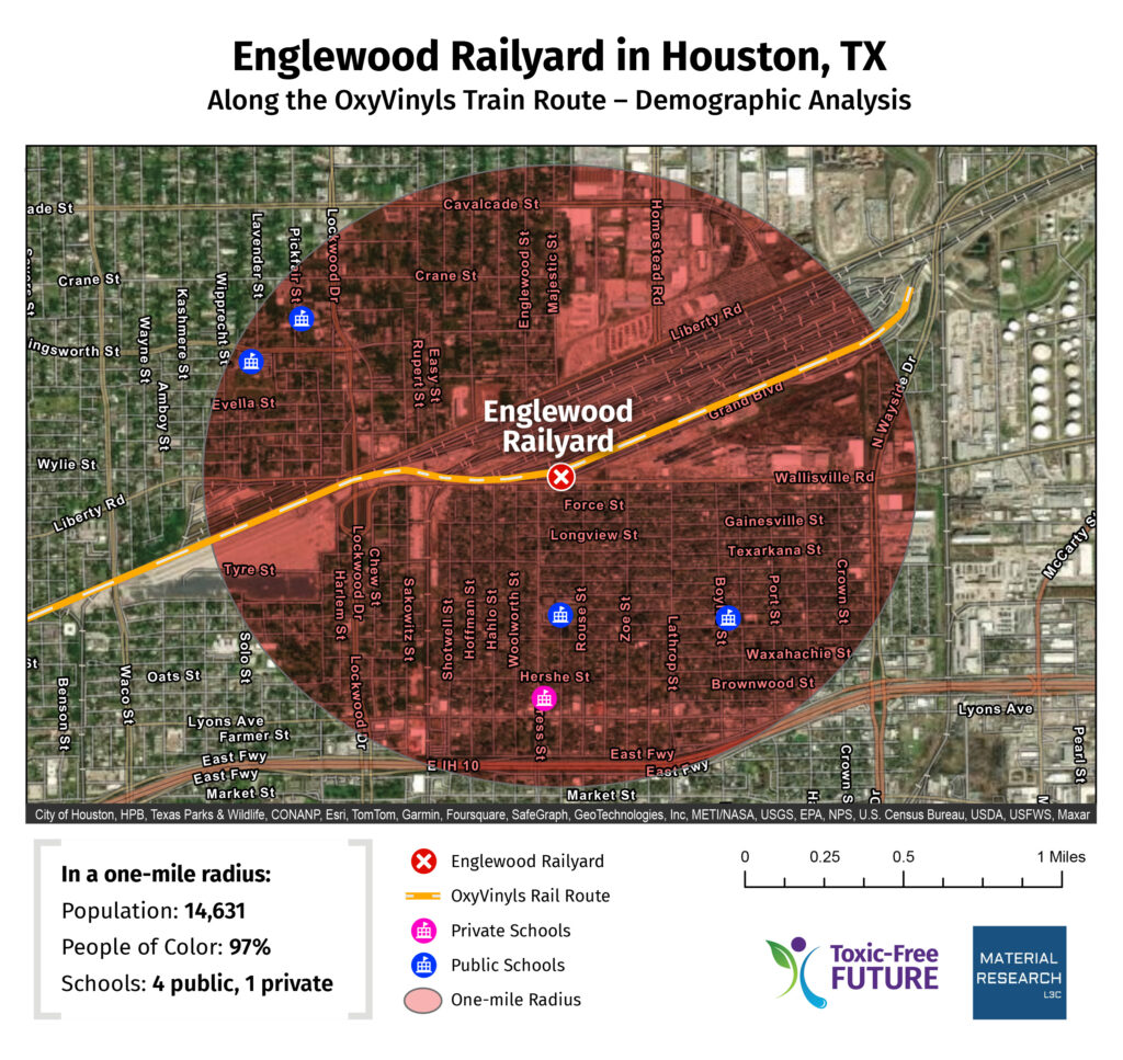
- Houston, TX – Residences of 14,631 people and five schools are located within a one-mile radius of the vinyl chloride train route through Houston; 97% of this population are people of color.31
- Toledo, OH– Residences of 11,259 people and four schools are located within a one-mile radius of the vinyl chloride train route through Toledo; 49% of this population are people of color.32
- Fort Wayne, IN– Residences of 10,170 people and five schools are located within a one-mile radius of the vinyl chloride train route through Fort Wayne; 35% of this population are people of color.33
- Little Rock, AR – Residences of 3,550 people and five schools are located within a one-mile radius of the vinyl chloride train route through Little Rock; 39% of this population are people of color.34

e A point was chosen along the route within the given city (with a population of 200,000 or more) based on the route’s proximity to the center of the city. A one-mile radius was set around the given point. The latitude and longitude were entered into the EPA EJ screen tool to collect demographic information. The public school and private school data were sourced through the National Center for Education Statistics, which collects its data from the U.S. Census Bureau’s American Community Survey.
Read the report
- I.Key findings
- II.PVC: The poison plastic
- III.How much vinyl chloride is shipped from OxyVinyls around the U.S. every year?
- IV.Maps: the toxic vinyl chloride train route from Texas to New Jersey
- V.Recent vinyl chloride train disasters
- VI.From rail cars to The Home Depot
- VII.Where does it all start? Fracking and vinyl chloride production in Texas
- VIII.Recommendations
- IX.Credits
- X.References
- XI.Methodology